
Add Your Tooltip Text Here
Add Your Tooltip Text Here
Add Your Tooltip Text Here
Add Your Tooltip Text Here
Add Your Tooltip Text Here
Add Your Tooltip Text Here
Add Your Tooltip Text Here
Add Your Tooltip Text Here
Add Your Tooltip Text Here
Add Your Tooltip Text Here
Add Your Tooltip Text Here
Add Your Tooltip Text Here
KALTJITI (formerly Fregon)
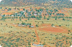
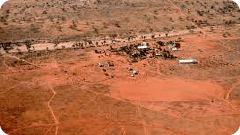
Kaltjiti (formerly Fregon) is an Aboriginal community in Anangu Pitjantjatjara Yankunytjatjara (APY lands) in South Australia, comprising one of the six main communities on “The Lands” (the others being Amata, Pukatja, Pipalyatjara, Indulkana and Mimili).
Kaltjiti (26.765°S 132.0333°E) is situated approximately 45 kms (28 mi) south of the Musgrave Ranges and lies west of the Everard Ranges. Kaltjiti is also situated approximately 137 kms (85 mi) from the Stuart Highway. Kaltjiti lies directly south of Umuwa and Ernabella/Pukatja. The community straddles the Officer Creek, which in turn flows from South Australia’s highest mountain, Ngarutjaranya. The creek is usually a dry sandy bed and only flows at times of very high rainfall.
In 1986 the population was recorded as 268; in 1991, it was 310 and in 1996 it was 299, according to the Australian Bureau of Statistics’ 1999 Yearbook.
In the 2001 Australian Census, the population was 245.
In 2006 and 2011, only the total count of Aboriginal and Torre Strait Islander people for “Kaltjiti (Fregon) and Inintata Homelands” area is available, with a total of 212 in 2006[5] and 242 in 2011.


